
4/6/2020
Good wet Monday morning,
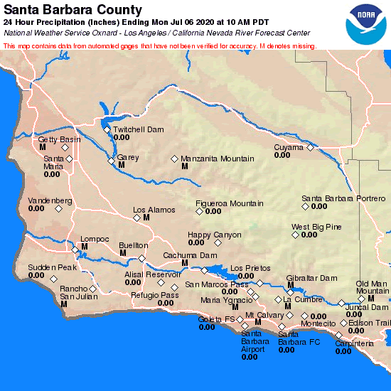
Great rain totals, especially on San Marcos Pass with 5.47 inches so FAR ….
https://www.cnrfc.noaa.gov/images/countyPrecipMaps/santabarbara_24HRprecip.png
The low pressure system is still well to the north and you can see the low pumping in the subtropical moisture over us from the south.
The heaviest rain is beginning to move south now and Ventura to LA will get the heavy rain that we have received.
https://www.star.nesdis.noaa.gov/GOES/conus_band.php?sat=G17&band=09&length=12
Rain totals all have been good. Santa Barbara and Montecito with the best rain totals. Montecito has seen around 2 inches and Santa Barbara 1.5 inches with more to come.
Today the heavier rain will turn to showers. The central coast and Santa Barbara county will see another 1/3 to an inch today.
Radar now:
Tonight and Tuesday morning, showers should begin to taper off, but will still be hit and miss rain. Tuesday afternoon there is a chance of thunderstorms.
Wednesday, the low moves to the East and wrap around showers are in the forecast, so mountain areas will see numerous showers wrapping into coastal areas.
Thursday it looks like we start to clear out. Depending on what model you look at, showers are still possible.
Friday dry with highs in the mid 60s with sunshine.
Saturday and Sunday looks like we will see a 5 degree jump in temp which might bring highs close to 70.
Hope everyone enjoys the late season storm, creeks are flowing and it is quite wet out there.
 Loading...
Testimontials
Thanks for the expertise, good job, right price, great attitude, and timing!David Eldred