
12/23/19
Good Monday morning,
That was quite a storm yesterday, our day started with sun then the south winds really started blowing. We had heavy rain for 6 hours.
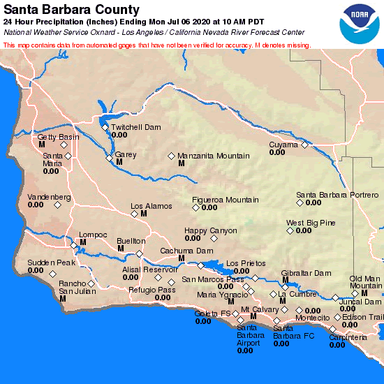
Rain total in the Santa Barbara and Ventura areas were quite impressive.
Santa Barbara and Montecito received 2.5 inches of rain in that short period. This was thanks to our south facing hill.
https://www.cnrfc.noaa.gov/images/countyPrecipMaps/santabarbara_24HRprecip.png
Today the low is spinning 400 miles to the west and moving south into Mexico before it swings to the East. Cold air has moved in. This is going to give us instability in the hills.
Pulling moisture from the subtropical jet into the area:
https://www.star.nesdis.noaa.gov/GOES/conus_band.php?sat=G17&band=09&length=12
The best chance for additional rain will be this afternoon, where some areas will see thunder showers. Santa Barbara to LA will see the most additional rain.
If you get caught in a thunderstorm, heavy rain will occur with 3/4 of an inch. Most areas will see an additional 1/4 to 3/4 of an inch today.
Tonight we dry out and Tuesday will be dry.
Tuesday night, the next system drops in. This is going to be a colder system arriving on Christmas Day. Looks like rain should start up by noon.
Models have struggled with this event. Yesterday they called for less rain. The last model run flipped and now has made this a stronger system.
Now looking like another round of heavy rain Christmas Day into Christmas night.
Thursday a few showers, but the system will move out, bringing Back dry weather.
Friday and Saturday look to be dry.
This week is short for some, but I have 1/2 weeks worth of hours this weekend alone.
Love the rain, just as long as it stays out of your house.
Here are the rain totals for the past 24 hours in Santa Barbara county.
 Loading...
Testimontials
Jack, Thank you for sending me a team that worked very well together, cleaned up in an excellent manner and produced an outstanding new-roof solution. Please do not hesitate to put our home on your list of places-to-showMartin Greenfield