
6/26/19
Good Wednesday morning,
Another day of drizzle. That will make 3 days in a row of measurable drizzle.
That is quite unusual, even for June. When we look back over the record books for 2019 there is going to be a lot of things that jump out for the rain season.
The good news is, the worst will be over after today. We will actually start to see the sun again in the afternoons.
Temps will begin to climb back to normal by the weekend.
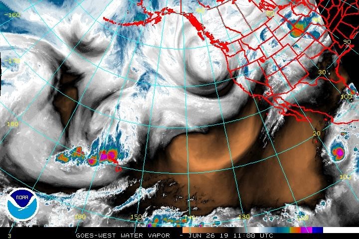
Still quite a bit of Action in the Pacific. There is a low pressure system in the Pacific Northwest.
Good rain near Hawaii, the first tropical depression near Cabo, but harmlessly spinning in the pacific.
https://www.ssd.noaa.gov/goes/west/nepac/wv-l.jpg
For us, just more fog and drizzle today. The marine layer is 2900 feet thick.
This will make for a very cool foggy, wet day. We will likely not see clearing along the coast from Malibu to Santa Barbara.
In the valleys, the sun should peak out in the afternoon.
Thursday we start to have some off shore affects, this will thin the marine layer and sun will prevail in the afternoons.
Friday will be a repeat of Thursday.
The weekend will allow more sun. Valleys will be sunny and climb into the 80s.
Coastal, still morning clouds, but sun will arrive by noon.
Next Tuesday a weak low arrives. Just a thicker marine layer.
The 4th of July.....still more than 7 days away, so the forecast is not accurate. Night and morning low clouds is still a good bet.
Ok, the sun is rising soon, day light is on it way, but no sun for us today.
Enjoy.
 Loading...
Testimontials
Thank you for coming up to do the demo for the Career Fair at Los Prietos. All the boys were fascinated by the chance to see how sheet metal is formed, and to do some of it themselves. A hands-on demo is always the most effective in getting the boys involved. We really appreciate your arranging the demo, especially since you had already put so much energy into the talk and demo you did for the Construction Technology class. The teaching and Probation staff were all impressed by how involved the boys were in your demo.Richard Anderson Instructor
Construction Technology Program Los Prietos Boys Camp