
1/6/2019
Good Sunday morning,
The rain arrived right on time yesterday, and it came down hard for a short period of time.
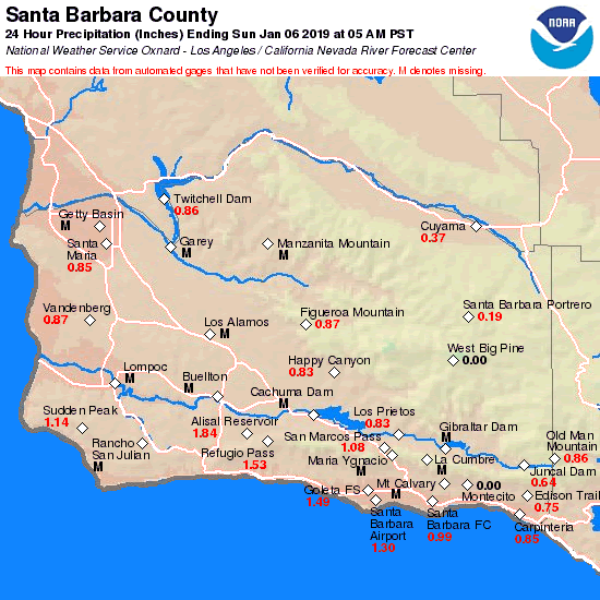
Fairly impressive totals for a 3 hour period of rain. All SB areas saw from .99 to 1.30 inches of rain.
https://www.cnrfc.noaa.gov/images/countyPrecipMaps/santabarbara_24HRprecip.png
We are looking to be in a wet pattern for the next week, with rain every other day.
Today will be relatively dry, but rain will start up again this evening and drop another round of rain over us, into Monday morning.
With this system we are expecting another 1/2 to 1 inch of rain. Snow level will jump to around 6500 feet.
Monday some morning showers, but it will clear out by noon.
Tuesday will be dry, but late in the day we are expecting another storm Tuesday night into Wednesday.
This is weaker and will not produce a lot of rain. Maybe 1/4 to 1/3 of a inch.
Thursday, a weak ridge pops up, this will keep us dry into Friday day.
Then Friday night, into and through the weekend, a double barreled low will affect our area.
Just the name makes you think this will be a real rain maker. Unfortunately it is just too far out there to call. Yet !
However, we will need to keep a strong eye on this, because if it does stay as a strong system we will see rainfall Friday night through Sunday.
With only a short break on Saturday afternoon, no rain fall predictions at this point, but welcome to the rainy season.
Enjoy it, we need the rain....
The good news is the ground is not saturated at this point, so run off has been light in creeks.
We will need to see how future systems saturate the ground, then run off will be greater.
Yesterday’s storm was intense, but the ground absorbed most of the rain.
As far as temps go, it will be cool days with most areas staying in the upper 50s for highs.
Lows will be in the 30s and 40s.
Here are the rain fall totals from yesterday.
 Loading...
Testimontials
Thank you for coming up to do the demo for the Career Fair at Los Prietos. All the boys were fascinated by the chance to see how sheet metal is formed, and to do some of it themselves. A hands-on demo is always the most effective in getting the boys involved. We really appreciate your arranging the demo, especially since you had already put so much energy into the talk and demo you did for the Construction Technology class. The teaching and Probation staff were all impressed by how involved the boys were in your demo.Richard Anderson Instructor
Construction Technology Program Los Prietos Boys Camp